Severe thunderstorms are producing widespread damaging winds across a part of the Midwest today as a derecho races eastward.
A derecho is a widespread wind damage event caused by severe thunderstorms, and this one got its start in eastern Nebraska Monday morning.

Residents in the Midwest felt the wrath of a derecho which left widespread damage and hundreds of thousands in the dark Monday afternoon.
Insane footage from the derecho moving through eastern Iowa this morning. This is from Belle Plaine, Iowa which is east of Des Moines but west of Cedar Rapids. #IAwx pic.twitter.com/nKdfonpveC
— Tyler Roney (@TylerJRoney) August 10, 2020
The severe storms marched eastward across Nebraska and Iowa, bringing wind gusts as high as 100 mph that easily downed large trees and caused some structural damage.
It picked up. pic.twitter.com/jP5ZGkaBlQ
— Deion Broxton (@DeionBroxton) August 10, 2020
The complex of storms has knocked out power and caused tree damage from around Omaha, Nebraska, to central Iowa.
Winds are insane right now in Cedar Rapids, if you are not inside you need to get inside NOW. From this Alliant tower. pic.twitter.com/6VyOatK1qo
— Ashley Neighbor (@ashneighbor) August 10, 2020
Winds gusted up to 112 mph in Midway, Iowa and up to 99 mph as these storms passed through Marshalltown, Iowa.
Strom damage in Des Moines:
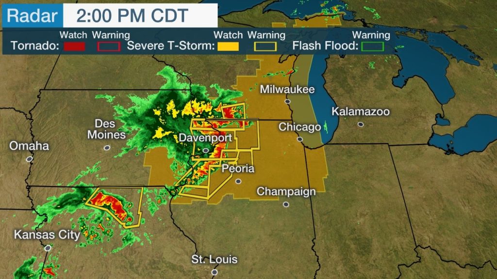
The severe thunderstorms are expected to track eastward into northern Illinois, far southern Wisconsin, northern Indiana and southwestern Michigan through the afternoon and early evening hours.
And this was in Grinnel, Iowa:
Tree damage, power outages and some structural damage will occur along the path of these thunderstorms, particularly in the purple-shaded areas of the map below. This includes the Chicago metro area by later this afternoon.
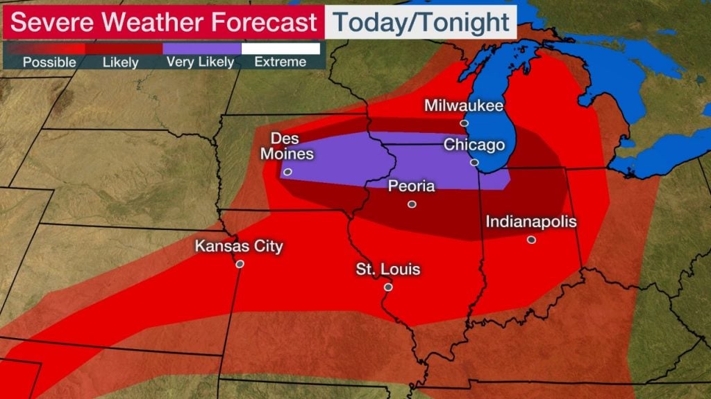
A severe thunderstorm watch is in effect until 7 p.m. CDT from eastern Iowa into southern Wisconsin and northern Illinois. NOAA’s Storm Prediction Center says this is a “particularly dangerous situation” and that wind gusts could top 80 mph in some locations.
Winds from a severe thunderstorm caused at least one truck to overturn on Interstate 380. I pulled up and called 911 immediately as these men helped the driver out. The woman in the video is an RN and checked on the driver who seems to be fine before taking him to her vehicle. pic.twitter.com/UjkvehavUc
— Andy Abeyta (@andy_abeyta) August 10, 2020
Another severe thunderstorm watch is in effect until 7 p.m. CDT for parts of eastern Wisconsin and Upper Michigan.
In Iowa alone, more than 400,000 homes and businesses were without power after the storms rolled through, according to PowerOutage.us.
Grain elevator smashed in Luther #iawx pic.twitter.com/eiCRlIWeJg
— Taylor Kanost (@WxKanost) August 10, 2020
Nebraska had nearly 50,000 additional customers in the dark at the height of the outages.
Straight-line winds caused this damage in Newton #iawx
— Taylor Kanost (@WxKanost) August 10, 2020
?: Gina Adams pic.twitter.com/vfxUgqmh4U
@NWSDesMoines Devastating damage in SE Boone/SW Story County. The door pictured was a 24’x18’ that was ripped from a north facing opening and was found 1/8 mile SE of the farm. All property owners okay we spoke with. pic.twitter.com/DRzgIFuS6L
— Kyle Williams (@ksw442) August 10, 2020
Illinois was hit hard by a derecho with winds of 70-115MPH, leaving behind a path of destruction.
Almost 700,000 Illinois residents are without power and 1.4 million in the region. It may be days before power is restored.
Widespread tree and line damage occurred in the state. Below are images of some of the damage.
Thoughts and prayers to all those impacted by these storms. More severe thunderstorm news on Strange Sounds and Steve Quayle. [Weather.com]
Now if you are looking for supplements to increase your healthy lifestyle and sexlife please visit Natural Health Source.


