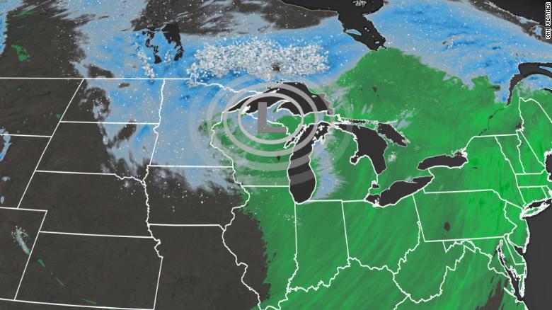
After China, now the US! The first significant winter storm of the season is impacting many across the Dakotas and Minnesota Friday morning. Blizzard conditions are ongoing as winds increase to over 30 to 40 mph across this region, where temperatures have plummeted to below average.
Heavy rain is falling on the warmer side of this storm system and eventually will swing through the Northeast by the early weekend, prompting the Weather Prediction Center (WPC) to issue a marginal risk – level 1 of 4 – for excessive rain Friday.
This strengthening and wide-ranging weather system will move east from Omaha, Nebraska, to New York City. Meanwhile, the West is experiencing an atmospheric river.
Veterans Day Storm in the Central USA with a new Storm bringing Flooding Rain for the Northwest. Big Chill to follow our Central to East Storm for the Weekend! Wind and Snow with even Blizzard Conditions in the Northern Plains. Be safe my friends! pic.twitter.com/3PpJsC0UID
— James Wilson (@tornadokid3) November 11, 2021
Season’s first snowfall to pack a punch
This storm system will usher in enough cold air to create snow and strong winds. This snowstorm is forecast to continue across the upper Midwest Friday.
“Much of the Upper Midwest is under some sort of winter alert as the season’s first significant snowfall is forecast,” says meteorologist Dave Hennen.
The snow and wind will gradually taper off toward the noon hour and into the afternoon. Before then expect areas of blowing snow and low visibility, especially over the Prairie Coteau. #sdwx #mnwx pic.twitter.com/I2xMCRwi2h
— NWS Aberdeen (@NWSAberdeen) November 12, 2021
Total snow accumulations will range from only 2 to 6 inches. But the winds will gust as high as 60 mph, creating whiteout conditions in portions of the Plains.
A blizzard warning is in place until midday Friday and covers most of northeast South Dakota.
“Travel should be restricted to emergencies only,” says the National Weather Service.
“A large and energetic low pressure system that has brought snow and high winds across the northern Plains and upper Midwest will steadily weaken today as it moves across the Great Lakes and then retreats into Canada tonight,” the Weather Prediction Center (WPC) says.
You may think it’s too early in the season to talk about snow, but if you’re across the upper Midwest, it’s pretty punctual, if not a few days early. Take, for example, Minneapolis/St. Paul, where the first snowfall of 1 inch or greater occurs around November 16. This Friday, the region could experience “numerous snow showers” that may be “heavy at times,” according to the Twin Cities National Weather Service office.
“Overnight Friday, light snow will move into parts of the Ohio Valley and the Great Lakes, as the snow over the Upper Mississippi Valley tapers off.”
Hennen says another storm this weekend “will drop south out of Canada and will bring a swath of snow to larger Midwest cities like Chicago, Milwaukee, Detroit and Cleveland.”
Heavy rain threat moves Northeast by the weekend
After the storm gives many their first taste of winter across the upper Midwest, it will continue to expand in size and move slowly eastward. The front half of the low pressure will draw precipitation and milder temperatures northward, allowing the threat for locally heavy rain from the Ohio Valley to New England.
[Weather Concerns Today] A 2-4 hour period of heavy rain, gusty winds and a few embedded t-storms are expected later today. Poor drainage street flooding, southerly wind gusts of 35-50 mph and even the low risk for isolated severe weather/localized damaging wind gusts. pic.twitter.com/sFK8DPMDTS
— NWS Boston (@NWSBoston) November 12, 2021
“As the system moves eastward, moisture from the Atlantic will stream into parts of the Northeast on Friday. The rain, heavy at times, will move into the Northeast/Mid-Atlantic and the Carolinas,” says the WPC.
This is why they have issued a marginal risk of excessive rainfall over parts of the Northeast on Friday into Saturday morning.
Rainfall totals will range between 1 to 2 inches through the early weekend. Still, localized accumulations could reach 2 to 4 inches across southern New England.
Rainfall will move through the major cities late morning through early afternoon.
Some of this rainfall could fall in only a matter of hours, increasing that risk for flash flooding.
“The associated heavy rain will create localized areas of flash flooding, affecting areas that experience rapid runoff with heavy rain,” the WPC says.
A cold front sweeping across the eastern half of the country through the weekend will bring an end to what has been a mild week and usher in chilly, more Fall-like temperatures. ? pic.twitter.com/VulTv4HJHt
— NWS Weather Prediction Center (@NWSWPC) November 11, 2021
Temperatures behind this storm system will plummet 15 to 25 degrees by the weekend for many East Coast cities, just enough to remind us that winter is right around the corner.
1 foot of snow in Alaska
Many Anchorage residents were shoveling sidewalks and brushing off car windshields for the first time this year as the town got hit by its largest snowstorm of the season.
Some parts of town are reporting over a foot of snow, including 15 inches reported as of 8:25 a.m. on Huffman and Birch Road on the Anchorage Hillside, according to the National Weather Service. Valdez reported 19 inches of powder at 6:40 a.m.
16.5″, still snowing. pic.twitter.com/pi8vC2Kezr
— Brian Brettschneider (@Climatologist49) November 11, 2021
The National Weather Service issued a winter weather advisory through Anchorage and the Mat-Su Borough until 4 p.m. on Thursday. There’s a winter storm warning in effect starting in Girdwood and covering the Southern Kenai Peninsula and Prince William Sound through 4 p.m. Thursday.
The storm largely bypassed the Kenai Peninsula, but snow flurries and winds mean driving conditions could be difficult from Homer to the Mat-Su Borough, according to Alaska 511.
Here’s your snow amounts as of 9am this morning, and it’s still snowing! Radar shows a band of moderate snow moving back and forth over the Anchorage area. Expect another 1-3″ of accumulation through midday. Continue to use caution while traveling. #akwx #snow pic.twitter.com/ouIPfxvOYy
— NWS Anchorage (@NWSAnchorage) November 11, 2021
NWS is forecasting up to four more inches of snow could fall throughout the day today in Anchorage. Forecasters say temperatures will drop to below normal for the rest of the week, so snow is likely to stay on the ground.
Highways and schools closed in Manitoba, Canada
Several highways remain closed while thousands of people are still without power Friday morning as Manitoba digs itself out of its first major snow dump of the season.
At least 17 highways are partly closed due to poor winter driving conditions, including the Trans-Canada Highway from Falcon Lake to the Ontario border, and between Brandon and Road 72 W.
Global’s @CoreyACallaghan has the latest on the first blast of snow moving out of Manitoba and when the next system is expected to hit. pic.twitter.com/L5KuWbS9Xq
— Global Winnipeg (@globalwinnipeg) November 12, 2021
The following divisions have closed schools for the day:
- Garden Valley School Division.
- Prairie Rose School Division.
- Red River Valley School Division.
- Sunrise School Division.
- Interlake School Division.
- Seine River School Division.
- Evergreen School Division.
- Beautiful Plains Division.
- Rolling River School Division.
- Hanover School Division.
- Lord Selkirk School Division.
- Whiteshell School Division.
Buses are also cancelled for some schools in Winnipeg. St. James-Assiniboia School Division is not operating buses to Headingley. Louis Riel School Division buses are cancelled east of Plessis Road and south of the Perimeter Highway. Pembina Trails School Division tweeted that it is not operating a number of bus routes today. Calvin Christian School is not running its rural bus service but is still operating its shuttle in Winnipeg.
A messy night on Manitoba roads. The gusty winds and snow expected to last through the night and into the Friday morning commute. #MBStorm #MBwx #Winnipeg pic.twitter.com/xpRgVcjWZO
— Corey Callaghan (@CoreyACallaghan) November 12, 2021
Meanwhile, as of 6:15 a.m., more than 5,000 people were still without power, according to Manitoba Hydro’s outage map.
The outages are scattered throughout southeastern Manitoba, but the highest number remain in the Selkirk area and communities around Lake Winnipeg.
The map says power is expected to be restored to most customers by Friday afternoon.
Today we’re working on restoring power to scattered outages caused by heavy snow across the province. We hope to have power restored to all customers by late today, depending on road conditions and whether we find additional damage. Thanks for your patience. pic.twitter.com/ZAdDgvsvcV
— Manitoba Hydro (@manitobahydro) November 12, 2021
Weather warnings
Several communities in central and southeastern Manitoba, including Winnipeg and Brandon, remain under snowfall warnings Friday morning.
Environment Canada says to expect heavy snow, gusty winds and blowing snow, ending later in the day. Winnipeg will likely get at least a couple more centimeters of snow, the weather agency says.
The following communities are also still under a winter storm warning:
Arborg, Hecla, Fisher River, Gypsumville and Ashern.
Ste. Rose, McCreary, Alonsa and Gladstone.
Selkirk, Gimli, Stonewall and Woodlands.
Those areas could see extremely heavy snowfall with very poor visibility Friday morning, made worse by high winds off Lake Winnipeg.
The wind is making it hard for Environment Canada to measure how much snow has fallen since the weather event began, meteorologist Eric Dykes said.
Generally, southern Manitoba has had between five and 15 centimeters, he said. The highest amount measured thus far was 32.5 centimeters in Pinawa, while Swan River has had 30. Meanwhile, Winnipeg has seen anywhere from nine to 15 centimeters in the last two days, Dykes said.
The mini Ice Age is here to stay! [CNN, AlaskaPublic, CBC]
Now subscribe to this blog to get more amazing news curated just for you right in your inbox on a daily basis (here an example of our new newsletter).
You can also follow us on Facebook and/ or Twitter. And, by the way you can also make a donation through Paypal. Thank you!
You should really subscribe to QFiles. You will get very interesting information about strange events around the world.


Winnipeg’s weather dude, looks like an ugly lesb0id? WTF is that creature?
Snow looks like normal, and plenty of it. That’s what usually happens in the Northeast and Midwest after October. Our snow hasn’t hit yet, but the trees all dropped their leaves, so we are due for 1-6″ and I love it. It keeps the roots moist during winter, and I rarely have to water my 250+ trees.
Rabbits are out fattening up for Winter. I didn’t hunt last weekend. Practically tripping over them this year. There’s one big fat male out on my north acres that is always in the same spot. I think I will bag him first. There’s a breeding pair under the waterfall boulders by the pond. They can hang out and make more baby rabbits for Spring. There’s a few out front too, but I haven’t figured out if they are rogue males, or a breeding pair yet, so they get a pass. Now that I fenced my acres, the yotes aren’t getting by, so the rabbits breed more. Owls are back for Winter too, so I probably will leave the front acre rabbits for them.
Enjoy the snow, and make some big snowmen for Christmas look and feel.