A rare August severe storm system rolled through the San Francisco Bay Area early Sunday.
People across the Bay Area woke to a wild mix of thunder, lightning, high winds and heavy rain early Sunday morning.
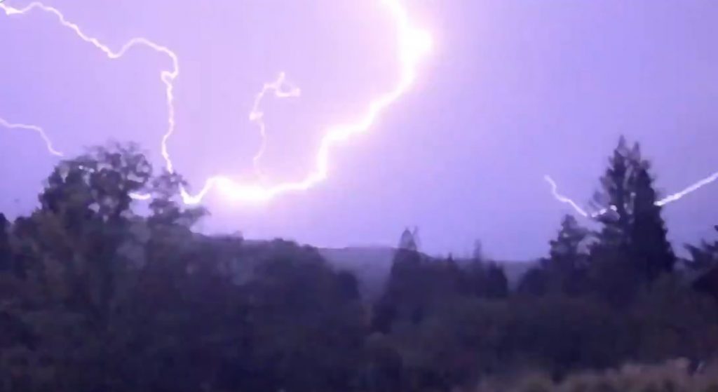
This is probably the most widespread and violent summer thunderstorm event in memory for Bay Area.
The National Weather Service on Sunday extended a red flag fire warning for the entire Bay Area until 11 a.m. Monday morning.
Additionally, the Red Flag Warning has been extended until tomorrow morning with more thunderstorms expected to develop. Lightning strikes will likely lead to new fire starts.#CAwx pic.twitter.com/MF5uhBurAe
— NWS Bay Area (@NWSBayArea) August 16, 2020
Dry lightning was in the forecast, but the thunderstorms were more severe and wet than expected and, at the end of a week marked by dry heat, the weather was a surprise for many. The weather was also unusual for California, which sees little storm activity in the summer months.
Rare thunder and lightning storm over the SF Bay Area. pic.twitter.com/OZQC5wJjbk
— Paul Robbins Holland (@paulrholland) August 16, 2020
Hundreds of lightning strikes were recorded, National Weather Service forecaster Drew Peterson said at 5 a.m. “We’re seeing nonstop continuous lightning across the Bay Area, especially the west side, not as much on the east side,” he said.
Wild night in the San Francisco Bay Area. This is probably the most widespread and violent summer thunderstorm event in memory for Bay Area, & it's also one of the hottest nights in years. Convective gusts 60+ mph; enormous amount of (partially dry) lightning. Wow. #CAwx #CAfire pic.twitter.com/Q5AOEQcqR7
— Daniel Swain (@Weather_West) August 16, 2020
At 5:30 a.m., new storms were firing over the ocean and moving toward the San Mateo peninsula. More storm activity is expected through 8 a.m. with the NWS warning of fallen trees and power lines, power outages, wildfire potential and difficulty driving in winds.
The National Weather Service said wind gusts generated by the fast-moving system were being clocked as high as 66 mph. NWS Forecasters reported gusts of 66 mph on Atlas Peak, 65 mph at Hawkeye, 48 mph at St. St Helena, 45 mph on Mt. Tam and 42 mph on Mt Diablo.
High winds downed PG&E lines, triggering power outages from neighborhoods in San Rafael all the way into western Marin County. Utility officials said 57,410 customers were without power — majority due to the lightning strikes. There were 23,093 in the North Bay, 14,200 in the South Bay and 14,020 in the East Bay.
Wondering where this moisture is coming from bringing us these thunderstorms? Check out this GOES-17 infrared imagery and follow the moisture back to Tropical Storm Fausto:
Wondering where this moisture is coming from bringing us these thunderstorms? Check out this GOES-17 infrared imagery and follow the moisture back to Tropical Storm Fausto#CAwx pic.twitter.com/cOWq5pABcs
— NWS Bay Area (@NWSBayArea) August 16, 2020
“This is the worst thing we want to see in terms of fire weather,” said Peterson. “The entire region is being inundated by lightning strikes. We’re probably getting widespread reports of fire strikes. The problem is the vegetation is really dry and we still have really dry air near the surface. Any lightning strikes that hit the ground are likely to start a fire.“
This is an INCREDIBLE amount of lightning moving into the Bay Area right now. Nearly 200 lightning strikes in the past 15 minutes! pic.twitter.com/5LLjJKnJye
— Drew Tuma (@DrewTumaABC7) August 16, 2020
He added that the thunderstorms and the heat are two separate air masses, with the storm moving across the region at about 10,000 feet while the hot air is only a few hundred feet above the Earth’s surface.
Wild lightning tonight along the coast, as seen from Pacifica, CA. #CAwx @NWSBayArea pic.twitter.com/WJhvq7l7lg
— Jeff (@Negative_Tilt) August 16, 2020
Even though the storms delivered a burst of cooler air, clouds and rain, the heat wave is expected to continue through Wednesday as the hot air mass remains settled across California.
It was dangerously hot for many in the Bay Area, some even broke their record high for today. Make sure you stay safe and weather aware!#CAwx pic.twitter.com/n9n4nPCS9a
— NWS Bay Area (@NWSBayArea) August 16, 2020
The intensity of the storm system triggered an early morning severe thunderstorm warning for the entire San Francisco Bay Area. The warning for Contra Costa, Alameda, Napa, San Francisco and Santa Clara counties was extended until 8 a.m. and even after it expired the lightning and thunder continued.
The weather service also issued a special marine warning for the waters of San Francisco, San Pablo, Suisun Bays and the west Delta.
More extreme weather news on Strange Sounds and Steve Quayle. [SFGate, CBS Local]
Now if you are looking for supplements to increase your healthy lifestyle please visit Natural Health Source.




The Earth is mother ship for all of us. Lets take care of it wisely.
didnt some bay area state sen/rep just indicate he wants to make sex between men and boys legal?
Yes! It’s sick! This event the same week San Fran Mayor introduced pedophilia bill which would legalize it. Jesus Christ is coming!
Links please I couldn’t find it. I agree Jesus is coming. But first the evil on earth will be like as never before. The church + state will enforce false worship. Remember the 4th Commandment.