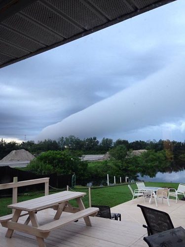
Dramatic cloud pictures in the sky of Venice, Florida.
Look at this roll cloud photos captured on September 23, 2014

Onlookers snapped dramatic photos of a roll cloud moving over Venice, Florida, on Tuesday morning.
A roll cloud is a type of arcus cloud, which is formed as cool air from a thunderstorm spreads out, forcing warm, moist air to rise in front of it, condensing into a cloud. It’s a low, horizontal, tube-shaped, and relatively rare type of arcus cloud.

This type of clouds is normally completely detached from other cloud features and usually appear to be “rolling” about a horizontal axis. They are a solitary wave called a soliton, which is a wave that has a single crest and moves without changing speed or shape.

One of the most famous frequent occurrences is the Morning Glory cloud in Queensland, Australia, which can occur up to four out of ten days in October. One of the main causes of the Morning Glory cloud is the mesoscale circulation associated with sea breezes that develop over the Cape York Peninsula and the Gulf of Carpentaria. However, similar features can be created by downdrafts from thunderstorms and are not exclusively associated with coastal regions.

This Florida roll cloud was created by a disturbance from the Gulf of Mexico which pushed across Florida on Monday and Monday night, triggering heavy showers and thunderstorms across the state.


