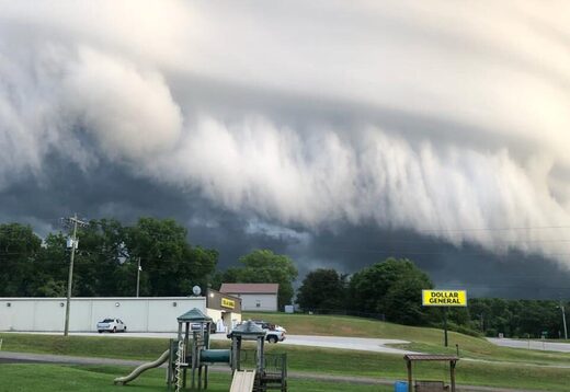
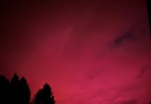
Look at these creepy pictures and videos of omnious looking clouds that engulfed parts of North Georgia on July 12th, 2021. The picture below was captured from River of Life Church in Nicholson, Georgia:

The ground-scrubbing cloud tendrils occur when the leading edge of cool, thunderstorm outflow acts as a wedge, forcing humid air upward ahead of the storm.
Jaymi Knight snapped these pics of ☁️’s in Commerce, Georgia on Monday evening. @NWSGSP @KendraKentWx @NWSAtlanta pic.twitter.com/ZXopfLpYm5
— Cody Alcorn (@CodyAlcorn) July 13, 2021
Now look at the apocalyptic cloud in this amazing video:
Here’s video of this cloud… pic.twitter.com/yFccP5eLKr
— Cody Alcorn (@CodyAlcorn) July 13, 2021
This shelf cloud is a scary-looking beast! It was the leading edge of a squall line creeping up from South Georgia.
This is one of the most incredible scenes I’ve ever seen. Talk about spooky! Shared with permission from Jaymi Knight in Commerce, Georgia. #gawx @spann @ReedTimmerAccu pic.twitter.com/ZShI9AgpOu
— Zachary Hall (@WxZachary) July 14, 2021
Here’s another video of the creepy storm cloud…
Anybody else see the shelf cloud yesterday? This was spotted in Jefferson, Georgia. ☁️? pic.twitter.com/EYJGI9zGQ9
— Everything Georgia (@GAFollowers) July 13, 2021
As if the thunderstorm had several layers… Terrifying!
Crazy shelf clouds from yesterday’s storms across north Georgia. First one is in Commerce from PJ Smith Rivera second in Jefferson from Tammy Schaefer. Thanks for sharing! pic.twitter.com/IxHDVEeWBK
— Jeff Hill (@jeffhillfox5) July 13, 2021
What are shelf clouds anyhow?
According to the NOAA Glossary, an Arcus cloud is, “a low, horizontal cloud formation associated with the leading edge of thunderstorm outflow (i.e., the gust front).”
Shelf and roll clouds are types of arcus clouds.
Tormenta en Commerce, Georgia, #US. (12.07.2021). #Shelf #Clouds #Storm #zabedrosky #Phenomenon pic.twitter.com/OPzBqz442G
— ⚠Climática Mundial? (@deZabedrosky) July 14, 2021
Shelf vs roll clouds
Shelf clouds are usually associated with rising cloud motion along the leading edge and rather turbulent looking skies beneath it. The thunderstorm outflow is the result of evaporation of raindrops behind the leading edge.
The more dense, evaporatively cooled air moves forward as a density current.
Outflow boundaries can also lift the air and initiate new storms.
In contrast, a roll cloud as, “A low, horizontal tube-shaped arcus cloud associated with a thunderstorm gust front (or sometimes with a cold front). In comparison to shelf clouds, they are typically detached from the base of the thunderstorm cloud.
Now subscribe to this blog to get more amazing news curated just for you right in your inbox on a daily basis (here an example of our new newsletter).
You can also follow us on Facebook and/ or Twitter. And, by the way you can also make a donation through Paypal. Thank you!
You should really subscribe to QFiles. You will get very interesting information about strange events around the world.


There will be signs on earth and in the sky before the great and terrible day of the Lord Jesus. People will see strange phenomenon and finally the earth will move away from the solar systems and day and night will be alike and the Lord will return. Be prepared so you will be able to stand in that day. Go to church, get baptized by immersion and keep God’s commandments including the 7th day sabbath as a memorial of creation. Be saved!
Remarkable.
Wish we could see inside the clouds. Couldn’t see any demon faces on the leading edge. Sometimes you can see angels and demons more easily in the clouds. Most people don’t notice.
Take pictures —one after the other, for a minute or two, next times a huge storm front moves in. Then examine the pictures slowly. You’ll see.